
Pittsburgh topographic map
Interactive map
Click on the map to display elevation.
About this map
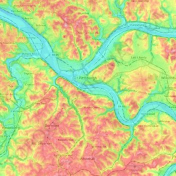
Name: Pittsburgh topographic map, elevation, terrain.
Location: Pittsburgh, Allegheny County, Pennsylvania, United States (40.36152 -80.09552 40.50120 -79.86573)
Average elevation: 303 m
Minimum elevation: 212 m
Maximum elevation: 413 m
The warmest month of the year in Pittsburgh is July, with a 24-hour average of 73.2 °F (22.9 °C). Conditions are often humid, and combined with highs reaching 90 °F (32 °C) on an average 9.5 days a year, a considerable heat index arises. The coolest month is January, when the 24-hour average is 28.8 °F (−1.8 °C), and lows of 0 °F (−18 °C) or below can be expected on an average 2.6 nights per year. Officially, record temperatures range from −22 °F (−30 °C), on January 19, 1994 to 103 °F (39 °C), which occurred three times, most recently on July 16, 1988; the record cold daily maximum is −3 °F (−19 °C), which occurred three times, most recently the day of the all-time record low, while, conversely, the record warm daily minimum is 82 °F (28 °C) on July 1, 1901. Due to elevation and location on the windward side of the Appalachian Mountains, 100 °F (38 °C)+ readings are very rare, and were last seen on July 15, 1995.
Other topographic maps
Click on a map to view its topography, its elevation and its terrain.
Cochrans Mill
United States > Pennsylvania > Allegheny County > Jefferson Hills
Cochrans Mill, Jefferson Hills, Allegheny County, Pennsylvania, 15129, United States
Average elevation: 311 m
Russellton
United States > Pennsylvania > Allegheny County > West Deer Township
Russellton, West Deer Township, Allegheny County, Pennsylvania, 15076, United States
Average elevation: 325 m
Plum
United States > Pennsylvania > Allegheny County
Plum, Allegheny County, Pennsylvania, 15239, United States
Average elevation: 332 m
Barking
United States > Pennsylvania > Allegheny County > Plum
Barking, Plum, Allegheny County, Pennsylvania, 15144, United States
Average elevation: 300 m
Edgeworth
United States > Pennsylvania > Allegheny County
Edgeworth, Allegheny County, Pennsylvania, United States
Average elevation: 266 m
Upper St. Clair
United States > Pennsylvania > Allegheny County
Upper St. Clair, Allegheny County, Pennsylvania, 15241, United States
Average elevation: 323 m
Wexford
United States > Pennsylvania > Allegheny County
Wexford, Pine Township, Allegheny County, Pennsylvania, 15090, United States
Average elevation: 361 m
Shaler Township
United States > Pennsylvania > Allegheny County
Shaler Township, Allegheny County, Pennsylvania, United States
Average elevation: 310 m
Ohio Township
United States > Pennsylvania > Allegheny County
Ohio Township, Allegheny County, Pennsylvania, United States
Average elevation: 333 m
Crescent Township
United States > Pennsylvania > Allegheny County
Crescent Township, Allegheny County, Pennsylvania, 15046, United States
Average elevation: 279 m
Fox Chapel
United States > Pennsylvania > Allegheny County
Fox Chapel, Allegheny County, Pennsylvania, 15238, United States
Average elevation: 315 m
Kilbuck Township
United States > Pennsylvania > Allegheny County
Kilbuck Township, Allegheny County, Pennsylvania, United States
Average elevation: 290 m
Ross Township
United States > Pennsylvania > Allegheny County
Ross Township, Allegheny County, Pennsylvania, 15237, United States
Average elevation: 332 m
Gibsonia
United States > Pennsylvania > Allegheny County > Richland Township > Gibsonia
Gibsonia, Richland Township, Allegheny County, Pennsylvania, 15044, United States
Average elevation: 348 m
Frick Park
United States > Pennsylvania > Allegheny County > Pittsburgh
Frick Park, Pittsburgh, Allegheny County, Pennsylvania, United States
Average elevation: 295 m
Pittock
United States > Pennsylvania > Allegheny County > Stowe Township
Pittock, Stowe Township, Allegheny County, Pennsylvania, 15136, United States
Average elevation: 277 m
Neville Island
United States > Pennsylvania > Allegheny County > Neville Township
Neville Island, Neville Township, Allegheny County, Pennsylvania, 15225, United States
Average elevation: 289 m
Findlay Township
United States > Pennsylvania > Allegheny County
Findlay Township, Allegheny County, Pennsylvania, United States
Average elevation: 335 m
Dorseyville
United States > Pennsylvania > Allegheny County > Indiana Township
Dorseyville, Indiana Township, Allegheny County, Pennsylvania, 15051, United States
Average elevation: 325 m
Friendship
United States > Pennsylvania > Allegheny County > Pittsburgh
Friendship, Pittsburgh, Allegheny County, Pennsylvania, United States
Average elevation: 289 m
East McKeesport
United States > Pennsylvania > Allegheny County
East McKeesport, Allegheny County, Pennsylvania, United States
Average elevation: 320 m
Indiana Township
United States > Pennsylvania > Allegheny County > Indiana Township
Indiana Township, Allegheny County, Pennsylvania, United States
Average elevation: 323 m
Etna
United States > Pennsylvania > Allegheny County > Etna
Etna, Allegheny County, Pennsylvania, United States
Average elevation: 274 m
Glenwillard
United States > Pennsylvania > Allegheny County > Crescent Township > Glenwillard
Glenwillard, Crescent Township, Allegheny County, Pennsylvania, 15046, United States
Average elevation: 278 m
Harrison Township
United States > Pennsylvania > Allegheny County
Harrison Township, Allegheny County, Pennsylvania, 15065, United States
Average elevation: 313 m
East Deer Township
United States > Pennsylvania > Allegheny County > East Deer Township
East Deer Township, Allegheny County, Pennsylvania, 15030, United States
Average elevation: 296 m
Coverdale
United States > Pennsylvania > Allegheny County > Bethel Park > Coverdale
Coverdale, Bethel Park, Allegheny County, Pennsylvania, 15102, United States
Average elevation: 354 m
Carnot
United States > Pennsylvania > Allegheny County > Moon Township > Carnot
Carnot, Moon Township, Allegheny County, Pennsylvania, 15046, United States
Average elevation: 336 m
Horning
United States > Pennsylvania > Allegheny County > Baldwin
Horning, Baldwin, Allegheny County, Pennsylvania, 15236, United States
Average elevation: 346 m
Clinton
United States > Pennsylvania > Allegheny County > Findlay Township > Clinton
Clinton, Findlay Township, Allegheny County, Pennsylvania, 15231, United States
Average elevation: 350 m
Turtle Creek
United States > Pennsylvania > Allegheny County > Turtle Creek
Turtle Creek, Allegheny County, Pennsylvania, 15145, United States
Average elevation: 286 m
Garden City
United States > Pennsylvania > Allegheny County > Monroeville
Garden City, Monroeville, Allegheny County, Pennsylvania, 15146, United States
Average elevation: 335 m
Oakmont
United States > Pennsylvania > Allegheny County
Oakmont, Allegheny County, Pennsylvania, 15139, United States
Average elevation: 268 m
Fairoaks
United States > Pennsylvania > Allegheny County > Leet Township > Fairoaks
Fairoaks, Leet Township, Allegheny County, Pennsylvania, 15003, United States
Average elevation: 269 m
Churchill
United States > Pennsylvania > Allegheny County
Churchill, Allegheny County, Pennsylvania, United States
Average elevation: 345 m