
Make a donation
Gear up for your next adventure:
As an Amazon Associate, this site earns from qualifying purchases at no extra cost to you.
Groves topographic map
Click on the map to display elevation.
Make a donation
Gear up for your next adventure:
As an Amazon Associate, this site earns from qualifying purchases at no extra cost to you.
Groves
According to the United States Census Bureau, Groves has an area of 5.2 square miles (13.4 km2), of which 0.015 square miles (0.04 km2), or 0.28%, is water. Most of the city sits at an elevation of 5 to 15 feet (1.5 to 4.6 m) above sea level.
Make a donation
Gear up for your next adventure:
As an Amazon Associate, this site earns from qualifying purchases at no extra cost to you.
About this map
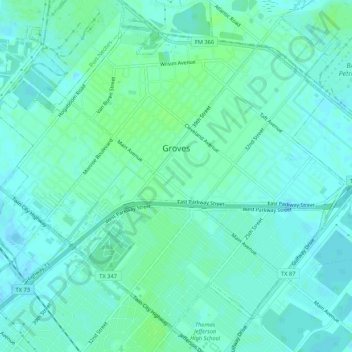
Name: Groves topographic map, elevation, terrain.
Location: Groves, Jefferson County, Texas, 77619, United States (29.92488 -93.94477 29.96423 -93.89173)
Average elevation: 4 m
Minimum elevation: -2 m
Maximum elevation: 9 m
Make a donation
Gear up for your next adventure:
As an Amazon Associate, this site earns from qualifying purchases at no extra cost to you.
Other topographic maps
Click on a map to view its topography, its elevation and its terrain.
Make a donation
Gear up for your next adventure:
As an Amazon Associate, this site earns from qualifying purchases at no extra cost to you.