
Sossenheim topographic map
Interactive map
Click on the map to display elevation.
About this map
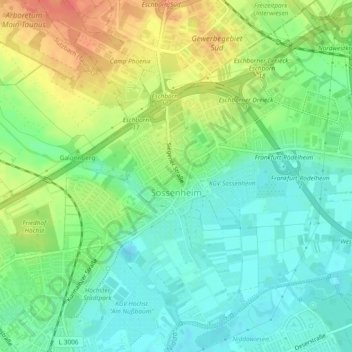
Name: Sossenheim topographic map, elevation, terrain.
Location: Sossenheim, West, Frankfurt, Hesse, 65936, Germany (50.10861 8.55144 50.13441 8.59847)
Average elevation: 111 m
Minimum elevation: 91 m
Maximum elevation: 140 m
Other topographic maps
Click on a map to view its topography, its elevation and its terrain.
Bergen-Enkheim
Bergen-Enkheim, Frankfurt, Hesse, 60388, Germany
Average elevation: 142 m
Nordend Ost
Nordend Ost, Innenstadt 3, Frankfurt, Hesse, 60316, Germany
Average elevation: 128 m