
Make a donation
Gear up for your next adventure:
As an Amazon Associate, this site earns from qualifying purchases at no extra cost to you.
Leganés topographic map
Click on the map to display elevation.
Make a donation
Gear up for your next adventure:
As an Amazon Associate, this site earns from qualifying purchases at no extra cost to you.
Leganés
The Relaciones or Descripciones by Francisco Antonio de Lorenzana (1784) provide information about the town's name, which the Leganés City Council has adopted as official. The following excerpt is taken from the updated edition of the Topographic Relations of Philip II, coordinated by Alfredo Alvar Ezquerra.
Make a donation
Gear up for your next adventure:
As an Amazon Associate, this site earns from qualifying purchases at no extra cost to you.
About this map
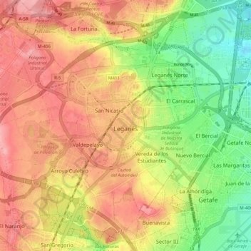
Name: Leganés topographic map, elevation, terrain.
Location: Leganés, Community of Madrid, Spain (40.29249 -3.81844 40.36555 -3.72089)
Average elevation: 656 m
Minimum elevation: 597 m
Maximum elevation: 704 m
Make a donation
Gear up for your next adventure:
As an Amazon Associate, this site earns from qualifying purchases at no extra cost to you.
Other topographic maps
Click on a map to view its topography, its elevation and its terrain.
Make a donation
Gear up for your next adventure:
As an Amazon Associate, this site earns from qualifying purchases at no extra cost to you.
La Maliciosa
Spain > Community of Madrid > Navacerrada
La Maliciosa is one of the most important and highest mountains of the Sierra de Guadarrama, a mountainous formation belonging to the Sistema Central. It has an altitude of 2227m above sea level and is located in the northwest of the Community of Madrid, in Spain, rising between La Pedriza, which lies to the…
Average elevation: 1,856 m
Sierra de Guadarrama
The range runs southwest–northeast, extending from the province of Ávila in the southwest, through the Community of Madrid, to the province of Segovia in the northeast. The range measures approximately 80 kilometres (50 mi) in length. Its highest peak is Peñalara, 2,428 metres (7,966 ft) in elevation.
Average elevation: 1,235 m
Make a donation
Gear up for your next adventure:
As an Amazon Associate, this site earns from qualifying purchases at no extra cost to you.
Make a donation
Gear up for your next adventure:
As an Amazon Associate, this site earns from qualifying purchases at no extra cost to you.
Fuenlabrada
Spain > Community of Madrid > Área metropolitana de Madrid y Corredor del Henares > Fuenlabrada
The founding of the village of Fuenlabrada has been tentatively traced to the late 14th century, populated by the dwellers of the nearby settlements of Loranca, Albas and Fregacedos, which had been simultaneously depopulated. The first mention of Fuenlabrada, which by the early 16th century was part of the…
Average elevation: 630 m
Loma del Rellano
Spain > Community of Madrid > Área metropolitana de Madrid y Corredor del Henares > San Sebastián de los Reyes
Average elevation: 687 m