Geolocate

Talisay topographic map

Click on the map to display elevation.

About this map

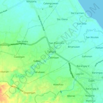
Name: Talisay topographic map, elevation, terrain.

Location: Talisay, Camarines Norte, Bicol Region, 4602, Philippines (14.09496 122.88373 14.17496 122.96373)

Average elevation: 10 m

Minimum elevation: 0 m

Maximum elevation: 36 m

Other topographic maps

Click on a map to view its topography, its elevation and its terrain.

Bagasbas Beach

Philippines > Camarines Norte > Daet > Bagasbas

Average elevation: 1 m

Daet

Philippines > Camarines Norte

Average elevation: 6 m

Vinzons

Philippines > Camarines Norte

Average elevation: 10 m

Tailon Island

Philippines > Camarines Norte

Average elevation: 0 m

Gear up for your next adventure:

🥾Hiking Boots - Waterproof and durable boots for long-distance hiking in the UK
🧺Ultralight Dry Bags - Organize and waterproof your gear inside your rucksack
🎒Hiking Backpacks - Comfortable backpacks for day hikes and multi-day treks
🧣Neck Gaiters - Protects against wind and sun on exposed ridges and peaks
🔋Solar Power Banks - Keep your GPS and phone charged during multi-day expeditions

As an Amazon Associate, this site earns from qualifying purchases at no extra cost to you.