Geolocate

Black Mountain topographic map

Click on the map to display elevation.

About this map
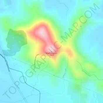
Name: Black Mountain topographic map, elevation, terrain.

Location: Black Mountain, Mackay, Mackay Regional, Queensland, Australia (-21.06920 149.09797 -21.06910 149.09807)

Average elevation: 95 m

Minimum elevation: 28 m

Maximum elevation: 291 m

Other topographic maps

Click on a map to view its topography, its elevation and its terrain.

Rural View

Australia > Queensland > Mackay

Average elevation: 15 m

Beaconsfield

Australia > Queensland > Mackay

Average elevation: 10 m

East Mackay

Australia > Queensland > Mackay

Average elevation: 4 m

Slade Point

Australia > Queensland > Mackay

Average elevation: 5 m

West Mackay

Australia > Queensland > Mackay

Average elevation: 8 m

Andergrove

Australia > Queensland > Mackay

Average elevation: 7 m

Mount Pleasant

Australia > Queensland > Mackay

Average elevation: 13 m

Beaconsfield

Australia > Queensland > Mackay

Average elevation: 10 m

Gear up for your next adventure:

🥄Titanium Camping Sporks - The ultimate lightweight utensil for trail meals
🥤Hydration Bladders - Hands-free hydration systems for backpacks
🎒Hiking Daypacks - Compact backpacks ideal for short hikes and excursions
🗺️Ordnance Survey Maps - Essential paper maps for hiking across the UK national parks
🧢Thermal Beanie Hats - Prevent heat loss from the head in windy summit conditions

As an Amazon Associate, this site earns from qualifying purchases at no extra cost to you.