
South Tyrol topographic map
Interactive map
Click on the map to display elevation.
About this map
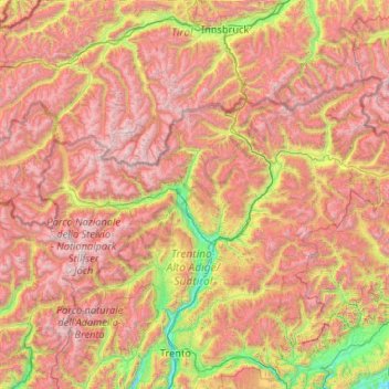
Name: South Tyrol topographic map, elevation, terrain.
Location: South Tyrol, Trentino – Alto Adige/Südtirol, Italy (46.21977 10.38180 47.09215 12.47797)
Average elevation: 1,725 m
Minimum elevation: 159 m
Maximum elevation: 3,832 m
Although some isolated massifs approach 4,000 metres (13,000 ft) and show strong glaciation (especially in the Ortler Alps and on the main ridge of the Alps), South Tyrol is by far dominated by mountains with altitudes of between 2,000 and 3,000 metres (6,600 and 9,800 ft). Among the multitude of peaks, the Dolomites are the highest in the Alps. Among the large number of peaks, three stand out for their alpine or cultural importance: the Ortler (3,905 metres, 12,812 ft) as the highest mountain in South Tyrol, the Schlern (2,563 metres, 8,409 ft) as the country's "landmark" and the Drei Zinnen (2,999 metres, 9,839 ft) as the center of alpine climbing. Other well-known mountains are the Königspitze (3,851 metres, 12,635 ft), the Weißkugel (3,739 metres, 12,267 ft), the Similaun (3,599 metres, 11,808 ft), the Hochwilde (3,480 metres, 11,417 ft), the Sarner Weißhorn (2,705 metres, 8,875 ft), the Hochfeiler (3,509 metres, 11,512 ft), the Dreiherrnspitze (3,499 metres, 11,480 ft), the Hochgall (3,436 metres, 11,273 ft), the Peitlerkofel (2,875 metres, 9,432 ft), the Langkofel (3,181 metres, 10,436 ft) and the Rosengartenspitze (2,981 metres, 9,780 ft).
Other topographic maps
Click on a map to view its topography, its elevation and its terrain.
Prämajur
Italy > Trentino – Alto Adige/Südtirol > South Tyrol > Schleis - Clusio
Prämajur, Schleis - Clusio, Mals - Malles Venosta, Vinschgau - Val Venosta, South Tyrol, Trentino – Alto Adige/Südtirol, 39024, Italy
Average elevation: 1,614 m
Piz Boè
Italy > Trentino – Alto Adige/Südtirol > South Tyrol > Corvara in Badia - Corvara
Piz Boè, Corvara in Badia - Corvara, Pustertal - Val Pusteria, South Tyrol, Trentino – Alto Adige/Südtirol, Italy
Average elevation: 2,664 m
Eppan an der Weinstraße - Appiano sulla Strada del Vino
Italy > Trentino – Alto Adige/Südtirol > South Tyrol
Eppan an der Weinstraße - Appiano sulla Strada del Vino, Überetsch-Unterland - Oltradige-Bassa Atesina, South Tyrol, Trentino – Alto Adige/Südtirol, 39057, Italy
Average elevation: 701 m
Milland - Millan
Italy > Trentino – Alto Adige/Südtirol > South Tyrol > Brixen - Bressanone
Milland - Millan, Brixen - Bressanone, Eisacktal - Valle Isarco, South Tyrol, Trentino – Alto Adige/Südtirol, 39042, Italy
Average elevation: 769 m
Molveno
Italy > Trentino – Alto Adige/Südtirol > Provincia di Trento
Molveno, Comunità della Paganella, Provincia di Trento, Trentino – Alto Adige/Südtirol, 38018, Italy
Average elevation: 1,558 m
Moos - Moso
Italy > Trentino – Alto Adige/Südtirol > South Tyrol
Moos - Moso, Sexten - Sesto, Pustertal - Val Pusteria, South Tyrol, Trentino – Alto Adige/Südtirol, 39030, Italy
Average elevation: 1,607 m
Daiano
Italy > Trentino – Alto Adige/Südtirol > Provincia di Trento
Daiano, Ville di Fiemme, Comunità territoriale della Val di Fiemme, Provincia di Trento, Trentino – Alto Adige/Südtirol, 38033, Italy
Average elevation: 1,211 m
Trento
Italy > Trentino – Alto Adige/Südtirol > Provincia di Trento
Trento, Territorio Val d'Adige, Provincia di Trento, Trentino – Alto Adige/Südtirol, 38121-38123, Italy
Average elevation: 786 m
Urtijëi - St. Ulrich in Gröden - Ortisei
Italy > Trentino – Alto Adige/Südtirol > South Tyrol
Urtijëi - St. Ulrich in Gröden - Ortisei, Salten-Schlern - Salto-Sciliar, South Tyrol, Trentino – Alto Adige/Südtirol, 39046, Italy
Average elevation: 1,689 m
Welschnofen - Nova Levante
Italy > Trentino – Alto Adige/Südtirol > South Tyrol
Welschnofen - Nova Levante, Salten-Schlern - Salto-Sciliar, South Tyrol, Trentino – Alto Adige/Südtirol, 39056, Italy
Average elevation: 1,535 m
Santa Cristina Gherdëina - St. Christina in Gröden - Santa Cristina Valgardena
Italy > Trentino – Alto Adige/Südtirol > South Tyrol
Santa Cristina Gherdëina - St. Christina in Gröden - Santa Cristina Valgardena, Salten-Schlern - Salto-Sciliar, South Tyrol, Trentino – Alto Adige/Südtirol, 39047, Italy
Average elevation: 1,935 m
Bondo
Italy > Trentino – Alto Adige/Südtirol > Provincia di Trento
Bondo, Sella Giudicarie, Comunità delle Giudicarie, Provincia di Trento, Trentino – Alto Adige/Südtirol, 38087, Italy
Average elevation: 1,040 m