
Make a donation
Gear up for your next adventure:
As an Amazon Associate, this site earns from qualifying purchases at no extra cost to you.
Lynch topographic map
Click on the map to display elevation.
Make a donation
Gear up for your next adventure:
As an Amazon Associate, this site earns from qualifying purchases at no extra cost to you.
Lynch
Lynch is located in eastern Harlan County at 36°57′54″N 82°55′00″W / 36.965133°N 82.916569°W / 36.965133; -82.916569 (36.965133, -82.916569), in the valley of Looney Creek. Lynch is the nearest city to Kentucky's highest point, Black Mountain (4,145 ft or 1,263 m). Sitting at an elevation of 1,716 feet (523 m) above sea level,
Make a donation
Gear up for your next adventure:
As an Amazon Associate, this site earns from qualifying purchases at no extra cost to you.
About this map
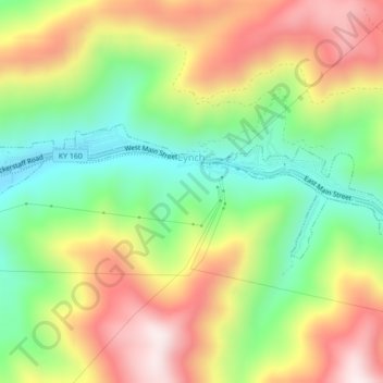
Name: Lynch topographic map, elevation, terrain.
Location: Lynch, Harlan County, Kentucky, United States (36.95704 -82.93565 36.96919 -82.89238)
Average elevation: 770 m
Minimum elevation: 487 m
Maximum elevation: 1,102 m
Make a donation
Gear up for your next adventure:
As an Amazon Associate, this site earns from qualifying purchases at no extra cost to you.