Geolocate

Douala topographic map

Click on the map to display elevation.

About this map

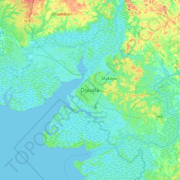
Name: Douala topographic map, elevation, terrain.

Location: Douala, Douala II, Communauté urbaine de Douala, Wouri, Littoral, Cameroon (3.88294 9.54620 4.20294 9.86620)

Average elevation: 15 m

Minimum elevation: -5 m

Maximum elevation: 92 m

Other topographic maps

Click on a map to view its topography, its elevation and its terrain.

Île Manoka

Cameroon > Littoral > Wouri > Douala VI

The island has an average elevation of 12 meters and 70% of the island has is below 10m above sea level.

Average elevation: 4 m

Douala III

Cameroon > Littoral > Wouri

Average elevation: 16 m

Gear up for your next adventure:

📚UK Hiking Guidebooks - Detailed route descriptions for the Lake District, Peaks, and Highlands
🔥Emergency Fire Starters - Reliable ignition tools for survival situations in damp conditions
🛰️Handheld GPS Devices - Reliable GPS units for hiking and outdoor navigation
🧺Ultralight Dry Bags - Organize and waterproof your gear inside your rucksack
🌄Outdoor Binoculars - Compact binoculars for landscape observation

As an Amazon Associate, this site earns from qualifying purchases at no extra cost to you.