
Calape topographic map
Click on the map to display elevation.
Calape
Most of the coastal area is a fairly level plain that gradually rises into rolling hills of coralline limestone. The highest point in Calape is Mount Candungao in the eastern portion of the town, with an elevation of 150 metres (500 ft) above sea level.
About this map
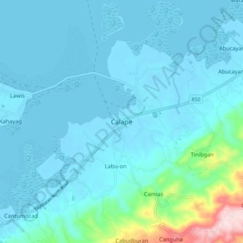
Name: Calape topographic map, elevation, terrain.
Location: Calape, Bohol, Central Visayas, 6328, Philippines (9.85051 123.83187 9.93051 123.91187)
Average elevation: 46 m
Minimum elevation: -6 m
Maximum elevation: 416 m
Other topographic maps
Click on a map to view its topography, its elevation and its terrain.
Rajah Sikatuna Protected Landscape
Philippines > Bohol > San Isidro
The Rajah Sikatuna park occupies the low mountain range in the south of Bohol island which corresponds geographically with the municipalities of Carmen, Sierra Bullones, Garcia Hernandez, Valencia, Dimiao, Bilar , Loboc and Batuan. It is characterized by rolling hills with remnants of natural forest on steep…
Average elevation: 349 m