Geolocate

Wheaton topographic map

Click on the map to display elevation.

About this map

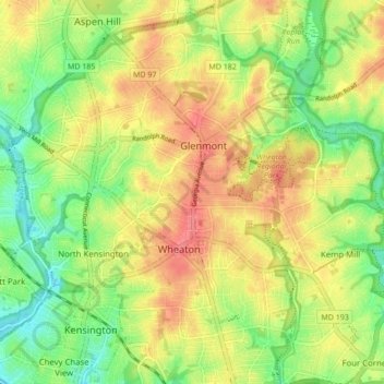
Name: Wheaton topographic map, elevation, terrain.

Location: Wheaton, Montgomery County, Maryland, 20902, United States (39.02201 -77.10925 39.07751 -77.02341)

Average elevation: 107 m

Minimum elevation: 67 m

Maximum elevation: 148 m

Other topographic maps

Click on a map to view its topography, its elevation and its terrain.

Gear up for your next adventure:

🛌Sleeping Bags - Warm and packable sleeping bags for outdoor nights
🎒Hiking Daypacks (20L) - Compact backpacks for day trips and technical mountain ascents
🍳Camping Stoves - Compact stoves for outdoor cooking
🔪Outdoor Multi-Tools - Versatile tools for gear repairs and food prep in the wild
🚶Walking Pedometers - Simple distance tracking for casual trail walkers

As an Amazon Associate, this site earns from qualifying purchases at no extra cost to you.