Geolocate

Ten Mile topographic map

Click on the map to display elevation.

About this map

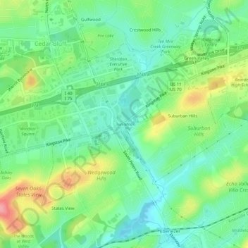
Name: Ten Mile topographic map, elevation, terrain.

Location: Ten Mile, Knoxville, Knox County, East Tennessee, Tennessee, 37923, United States (35.89341 -84.09963 35.93341 -84.05963)

Average elevation: 291 m

Minimum elevation: 257 m

Maximum elevation: 356 m

Other topographic maps

Click on a map to view its topography, its elevation and its terrain.

Gear up for your next adventure:

🛰️Outdoor GPS Navigation - Navigation devices for remote and off-grid areas
🔪Outdoor Multi-Tools - Versatile tools for gear repairs and food prep in the wild
🥤Hydration Bladders - Hands-free hydration systems for backpacks
🧢Waterproof Hiking Hats - Keep the rain off your face while studying topographic maps
📕Outdoor Navigation Books - Learn traditional and modern navigation techniques

As an Amazon Associate, this site earns from qualifying purchases at no extra cost to you.