Geolocate

Poissy topographic map

Click on the map to display elevation.

About this map

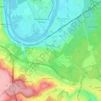
Name: Poissy topographic map, elevation, terrain.

Location: Poissy, Saint-Germain-en-Laye, Yvelines, Ile-de-France, Metropolitan France, 78300, France (48.89109 1.97952 48.95704 2.07070)

Average elevation: 67 m

Minimum elevation: 17 m

Maximum elevation: 173 m

Other topographic maps

Click on a map to view its topography, its elevation and its terrain.

Hautvilliers

France > Ile-de-France > Yvelines > Chevreuse

Average elevation: 127 m

Rodon

France > Ile-de-France > Yvelines

Average elevation: 167 m

La Corse

France > Ile-de-France > Yvelines > Élancourt

Average elevation: 165 m

Versailles

France > Ile-de-France > Yvelines > Versailles > Versailles

Average elevation: 143 m

Garnes

France > Ile-de-France > Yvelines > Senlisse

Average elevation: 150 m

Château de Beynes

France > Ile-de-France > Yvelines > Beynes

Average elevation: 91 m

Gear up for your next adventure:

🧰First Aid Kits - Essential safety kits for outdoor activities
📱Rugged Phone Cases - Heavy-duty protection for smartphones used as secondary GPS tools
🧭Emergency Beacons - Safety beacons for remote outdoor locations
🛑Emergency Bivvy Bags - Heat-reflective survival bags for unexpected nights out
🔋Power Banks - Portable chargers for long outdoor trips

As an Amazon Associate, this site earns from qualifying purchases at no extra cost to you.