Geolocate

Solana topographic map

Click on the map to display elevation.

About this map

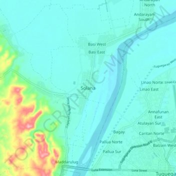
Name: Solana topographic map, elevation, terrain.

Location: Solana, Cagayan, Cagayan Valley, 3503, Philippines (17.61094 121.65092 17.69094 121.73092)

Average elevation: 33 m

Minimum elevation: 9 m

Maximum elevation: 154 m

Other topographic maps

Click on a map to view its topography, its elevation and its terrain.

Santa Praxedes

Philippines > Cagayan

Average elevation: 157 m

Gear up for your next adventure:

🎒Hiking Child Carriers - Explore the outdoors with the whole family safely
👟Waterproof Leg Gaiters - Keep mud and water out of your boots in boggy terrain
🧴Tick Removal Tools - Small, essential health tool for UK woodland and moorland
👟Women's Trail Running Shoes - Agile footwear for fell running and technical trails
🪢Paracord - Multi-purpose cord for camping and survival

As an Amazon Associate, this site earns from qualifying purchases at no extra cost to you.