
Thank you for supporting this site ❤️
Make a donation
Make a donation
Gear up for your next adventure:
As an Amazon Associate, this site earns from qualifying purchases at no extra cost to you.
Aritao topographic map
Click on the map to display elevation.
Thank you for supporting this site ❤️
Make a donation
Make a donation
Gear up for your next adventure:
As an Amazon Associate, this site earns from qualifying purchases at no extra cost to you.
About this map
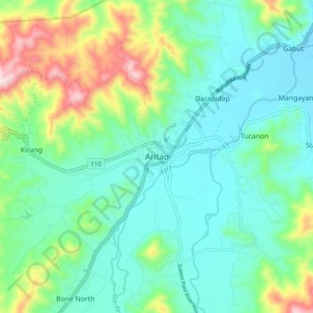
Name: Aritao topographic map, elevation, terrain.
Location: Aritao, Nueva Vizcaya, Cagayan Valley, 3704, Philippines (16.25689 120.99407 16.33689 121.07407)
Average elevation: 467 m
Minimum elevation: 346 m
Maximum elevation: 819 m
Thank you for supporting this site ❤️
Make a donation
Make a donation
Gear up for your next adventure:
As an Amazon Associate, this site earns from qualifying purchases at no extra cost to you.