
Syracuse topographic map
Interactive map
Click on the map to display elevation.
About this map
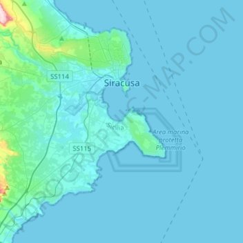
Name: Syracuse topographic map, elevation, terrain.
Location: Syracuse, Siracusa, Sicily, Italy (36.94771 15.08297 37.11567 15.33673)
Average elevation: 19 m
Minimum elevation: 0 m
Maximum elevation: 354 m
Other topographic maps
Click on a map to view its topography, its elevation and its terrain.
Palazzolo Acreide
Palazzolo Acreide, Siracusa, Sicily, 96010, Italy
Average elevation: 573 m
Carlentini
Italy > Sicily > Siracusa > Carlentini
Carlentini, Siracusa, Sicily, 96013, Italy
Average elevation: 188 m