Geolocate

Nijmegen topographic map

Click on the map to display elevation.

About this map
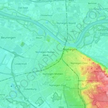
Name: Nijmegen topographic map, elevation, terrain.

Location: Nijmegen, Gelderland, Netherlands (51.79059 5.75762 51.89462 5.90835)

Average elevation: 19 m

Minimum elevation: 1 m

Maximum elevation: 95 m

Other topographic maps

Click on a map to view its topography, its elevation and its terrain.
Nijmegen

Netherlands > Gelderland > Nijmegen

Average elevation: 16 m

Kops Plateau

Netherlands > Gelderland > Nijmegen

Average elevation: 36 m

Gear up for your next adventure:

👟Waterproof Leg Gaiters - Keep mud and water out of your boots in boggy terrain
🥾Trekking Poles - Poles to improve stability on uneven terrain
🧊Insulated Flasks - Keeps drinks hot or cold during hikes
🥫Expedition Meals - Lightweight, high-calorie nutrition for long-distance hikers
🦯Walking Poles - Supportive poles for long-distance walking

As an Amazon Associate, this site earns from qualifying purchases at no extra cost to you.