
Make a donation
Gear up for your next adventure:
As an Amazon Associate, this site earns from qualifying purchases at no extra cost to you.
Evol topographic map
Click on the map to display elevation.
Make a donation
Gear up for your next adventure:
As an Amazon Associate, this site earns from qualifying purchases at no extra cost to you.
About this map
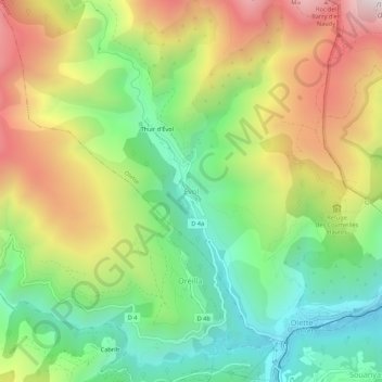
Name: Evol topographic map, elevation, terrain.
Average elevation: 1,055 m
Minimum elevation: 599 m
Maximum elevation: 1,693 m
Make a donation
Gear up for your next adventure:
As an Amazon Associate, this site earns from qualifying purchases at no extra cost to you.
Other topographic maps
Click on a map to view its topography, its elevation and its terrain.
Make a donation
Gear up for your next adventure:
As an Amazon Associate, this site earns from qualifying purchases at no extra cost to you.
Prats-de-Mollo-la-Preste
France > Occitania > Pyrénées-Orientales
Prats-de-Mollo-la-Preste is located in the Pyrenees, 13 km (8.1 mi) from the Spanish border and the Autonomous Community of Catalonia, on the banks of the river Tech, and on the south face of the Canigou at an elevation of 735 meters.
Average elevation: 1,295 m
Make a donation
Gear up for your next adventure:
As an Amazon Associate, this site earns from qualifying purchases at no extra cost to you.
Lac des Bouillouses
France > Occitania > Pyrénées-Orientales > Angoustrine-Villeneuve-des-Escaldes
Lac des Bouillouses or Llac de la Bollosa is a lake in Pyrénées-Orientales, France. At an elevation of 2017 m, its surface area is 1.49 km².
Average elevation: 2,091 m
Make a donation
Gear up for your next adventure:
As an Amazon Associate, this site earns from qualifying purchases at no extra cost to you.
Céret
France > Occitania > Pyrénées-Orientales
The town lies in the foothills of the Pyrénées mountains, in southern France, on the river Tech at an altitude of 175–1400 meters. It is 7 km (4.3 mi) from the Autoroute A9, 200 km (120 mi) from Montpellier, 250 km (160 mi) from Toulouse and 180 km (110 mi) from Barcelona. The GR 10 footpath runs close by.
Average elevation: 454 m
Saint-Paul-de-Fenouillet
France > Occitania > Pyrénées-Orientales > Saint-Paul-de-Fenouillet
Average elevation: 427 m
Make a donation
Gear up for your next adventure:
As an Amazon Associate, this site earns from qualifying purchases at no extra cost to you.
Make a donation
Gear up for your next adventure:
As an Amazon Associate, this site earns from qualifying purchases at no extra cost to you.
Angoustrine-Villeneuve-des-Escaldes
France > Occitania > Pyrénées-Orientales
Average elevation: 2,049 m