Geolocate

Reedsport topographic map

Click on the map to display elevation.

About this map

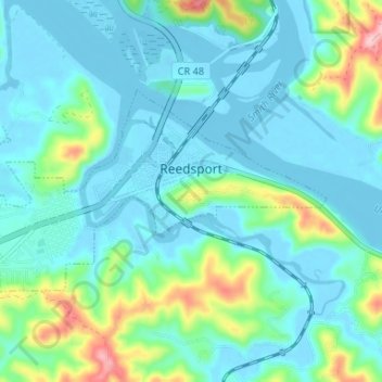
Name: Reedsport topographic map, elevation, terrain.

Location: Reedsport, Douglas County, Oregon, 97467, United States (43.68648 -124.13953 43.71193 -124.07363)

Average elevation: 34 m

Minimum elevation: -8 m

Maximum elevation: 176 m

Other topographic maps

Click on a map to view its topography, its elevation and its terrain.

Scottsburg

United States > Oregon > Douglas County

Average elevation: 168 m

Tenmile

United States > Oregon > Douglas County

Average elevation: 279 m

Umpqua

United States > Oregon > Douglas County

Average elevation: 137 m

Diamond Lake

United States > Oregon > Douglas County

Average elevation: 1,632 m

Dillard

United States > Oregon > Douglas County

Average elevation: 202 m

Rice Hill

United States > Oregon > Douglas County

Average elevation: 241 m

Glide

United States > Oregon > Douglas County

Average elevation: 259 m

Azalea

United States > Oregon > Douglas County

Average elevation: 604 m

Toketee Falls

United States > Oregon > Douglas County

Average elevation: 865 m

Tyee

United States > Oregon > Douglas County

Average elevation: 217 m

Wits End

United States > Oregon > Douglas County

Average elevation: 1,930 m

Azalea

United States > Oregon > Douglas County

Average elevation: 604 m

Gear up for your next adventure:

🧭Emergency Beacons - Safety beacons for remote outdoor locations
🧊Personal Water Filters - Drink safely from mountain streams marked on your map
🎒Hiking Backpacks - Comfortable backpacks for day hikes and multi-day treks
🧤Hiking Gloves - Warm and durable gloves for cold-weather walks
🥤Hydration Bladders - Hands-free hydration systems for backpacks

As an Amazon Associate, this site earns from qualifying purchases at no extra cost to you.