Geolocate

Newcastle topographic map

Click on the map to display elevation.

About this map
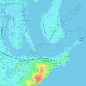
Name: Newcastle topographic map, elevation, terrain.

Location: Newcastle, Newcastle-Maitland, New South Wales, 2300, Australia (-32.93781 151.75963 -32.90148 151.80393)

Average elevation: 5 m

Minimum elevation: -3 m

Maximum elevation: 76 m

Other topographic maps

Click on a map to view its topography, its elevation and its terrain.
Jesmond Park

Australia > New South Wales > Newcastle

Average elevation: 35 m

Cameron Park

Australia > New South Wales > Newcastle

Average elevation: 23 m

Glenrock Lagoon

Australia > New South Wales > Newcastle

Average elevation: 39 m

Nobbys Beach

Australia > New South Wales > Newcastle

Average elevation: 3 m

Redhead Bluff

Australia > New South Wales > Newcastle

Average elevation: 13 m

Dixon Park

Australia > New South Wales > Newcastle

Average elevation: 12 m

Gear up for your next adventure:

☕Insulated Travel Mugs - Keep drinks hot while surveying the landscape from a summit
🥄Titanium Camping Sporks - The ultimate lightweight utensil for trail meals
🧥Breathable Waterproof Jackets - Essential rain protection for the unpredictable British climate
🧤Thermal Touchscreen Gloves - Stay warm while operating your GPS or smartphone camera
🔋Power Banks - Portable chargers for long outdoor trips

As an Amazon Associate, this site earns from qualifying purchases at no extra cost to you.