
Make a donation
Gear up for your next adventure:
As an Amazon Associate, this site earns from qualifying purchases at no extra cost to you.
Khartoum topographic map
Click on the map to display elevation.
Make a donation
Gear up for your next adventure:
As an Amazon Associate, this site earns from qualifying purchases at no extra cost to you.
Khartoum
In 1821, Khartoum was established 24 km (15 mi) north of the ancient city of Soba, by Isma'il Kamil Pasha, the third son of Egypt's ruler, Muhammad Ali Pasha, who had just incorporated Sudan into his realm. Originally, Khartoum served as an outpost for the Egyptian Army. Egypt shifted the seat of the colonial government from Wad Madani to Khartoum in 1823, which became a permanent settlement and underwent rapid development in the next decades. With its elevation to capital status, Khartoum quickly grew into a regional center of trade, serving as a rest area on the caravan route from Ethiopia to Egypt, but also becoming a major focal point for the slave trade.
Make a donation
Gear up for your next adventure:
As an Amazon Associate, this site earns from qualifying purchases at no extra cost to you.
About this map
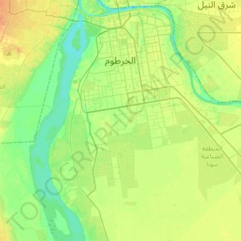
Name: Khartoum topographic map, elevation, terrain.
Location: Khartoum, Al Khartum State, Sudan (15.38765 32.45915 15.61680 32.71226)
Average elevation: 384 m
Minimum elevation: 372 m
Maximum elevation: 398 m
Make a donation
Gear up for your next adventure:
As an Amazon Associate, this site earns from qualifying purchases at no extra cost to you.
Other topographic maps
Click on a map to view its topography, its elevation and its terrain.
Make a donation
Gear up for your next adventure:
As an Amazon Associate, this site earns from qualifying purchases at no extra cost to you.