Geolocate

Ludlow topographic map

Click on the map to display elevation.

About this map

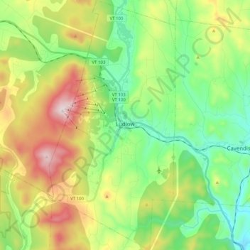
Name: Ludlow topographic map, elevation, terrain.

Location: Ludlow, Windsor County, Vermont, United States (43.32243 -72.76235 43.46829 -72.66080)

Average elevation: 496 m

Minimum elevation: 213 m

Maximum elevation: 1,011 m

Other topographic maps

Click on a map to view its topography, its elevation and its terrain.

Notown

United States > Vermont > Windsor County

Average elevation: 554 m

Grahamville

United States > Vermont > Windsor County > Ludlow

Average elevation: 428 m

Pompanoosuc

United States > Vermont > Windsor County > Norwich

Average elevation: 178 m

The Alps

United States > Vermont > Windsor County > Reading

Average elevation: 551 m

South Royalton

United States > Vermont > Windsor County

Average elevation: 239 m

Reedville

United States > Vermont > Windsor County > Chester

Average elevation: 359 m

Millbrook

United States > Vermont > Windsor County > Pomfret

Average elevation: 289 m

The Alps

United States > Vermont > Windsor County > Reading

Average elevation: 551 m

New Boston

United States > Vermont > Windsor County > Norwich

Average elevation: 322 m

Gaysville

United States > Vermont > Windsor County

Average elevation: 360 m

Pompanoosuc

United States > Vermont > Windsor County > Norwich

Average elevation: 178 m

The Alps

United States > Vermont > Windsor County > Reading

Average elevation: 551 m

Chester

United States > Vermont > Windsor County > Chester > Chester

Average elevation: 237 m

Gear up for your next adventure:

🛰️Outdoor GPS Navigation - Navigation devices for remote and off-grid areas
🥾Hiking Boots - Waterproof and durable boots for long-distance hiking in the UK
🍳Camping Stoves - Compact stoves for outdoor cooking
🧴Tick Removal Tools - Small, essential health tool for UK woodland and moorland
🛌Sleeping Bags - Warm and packable sleeping bags for outdoor nights

As an Amazon Associate, this site earns from qualifying purchases at no extra cost to you.