
Ψαροβότανο topographic map
Interactive map
Click on the map to display elevation.
About this map
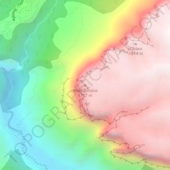
Name: Ψαροβότανο topographic map, elevation, terrain.
Average elevation: 1,191 m
Minimum elevation: 480 m
Maximum elevation: 1,876 m
Other topographic maps
Click on a map to view its topography, its elevation and its terrain.
North Tzoumerka Municipality
Greece > Epirus and Western Macedonia > Ioannina Regional Unit
Average elevation: 990 m
Ioannina
Greece > Epirus and Western Macedonia > Ioannina Regional Unit
Ioannina (Greek: Ιωάννινα Ioánnina [i.oˈa.ni.na] ), often called Yannena (Γιάννενα Yánnena [ˈʝa.ne.na]) within Greece, is the capital and largest city of the Ioannina regional unit and of Epirus, an administrative region in north-western Greece. According to the 2011 census, the city…
Average elevation: 493 m