
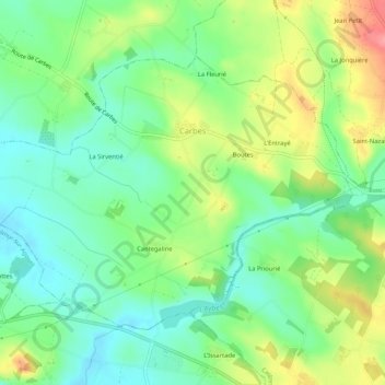
Carbes topographic map
Interactive map
Click on the map to display elevation.
About this map
Name: Carbes topographic map, elevation, terrain.
Average elevation: 196 m
Minimum elevation: 163 m
Maximum elevation: 252 m
Other topographic maps
Click on a map to view its topography, its elevation and its terrain.
Lagarrigue
Lagarrigue, Castres, Tarn, Occitania, Metropolitan France, 81090, France
Average elevation: 213 m
Saint-Sulpice-la-Pointe
Saint-Sulpice-la-Pointe, Castres, Tarn, Occitania, Metropolitan France, 81370, France
Average elevation: 138 m
Pampelonne
Pampelonne, Albi, Tarn, Occitania, Metropolitan France, 81190, France
Average elevation: 398 m
Lescure-d'Albigeois
Lescure-d'Albigeois, Albi, Tarn, Occitania, Metropolitan France, 81380, France
Average elevation: 200 m
Las Planes
France > Occitania > Tarn > Senouillac > Las Planes
Las Planes, Senouillac, Albi, Tarn, Occitania, Metropolitan France, 81600, France
Average elevation: 192 m
Le Vintrou
France > Occitania > Tarn > Le Vintrou
Le Vintrou, Castres, Tarn, Occitania, Metropolitan France, 81240, France
Average elevation: 610 m
Cambon-lès-Lavaur
Cambon-lès-Lavaur, Castres, Tarn, Occitania, Metropolitan France, 81470, France
Average elevation: 230 m