
Make a donation
Gear up for your next adventure:
As an Amazon Associate, this site earns from qualifying purchases at no extra cost to you.
Graaf-Reinet topographic map
Click on the map to display elevation.
Make a donation
Gear up for your next adventure:
As an Amazon Associate, this site earns from qualifying purchases at no extra cost to you.
About this map
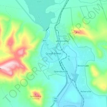
Name: Graaf-Reinet topographic map, elevation, terrain.
Average elevation: 873 m
Minimum elevation: 716 m
Maximum elevation: 1,396 m
Make a donation
Gear up for your next adventure:
As an Amazon Associate, this site earns from qualifying purchases at no extra cost to you.
Other topographic maps
Click on a map to view its topography, its elevation and its terrain.
Nqweba Dam
South Africa > Eastern Cape > Sarah Baartman District Municipality > Camdeboo Local Municipality > Graaf-Reinet
Average elevation: 815 m
Camdeboo National Park
South Africa > Eastern Cape > Sarah Baartman District Municipality > Camdeboo Local Municipality
The park is located on the southern foothills of the Sneeuberg Mountain ranges, with an elevation of between 740 and 1480 metres above sea level.
Average elevation: 837 m
Junction 6
South Africa > Eastern Cape > Sarah Baartman District Municipality > Camdeboo Local Municipality
Average elevation: 799 m