
Thank you for supporting this site ❤️
Make a donation
Make a donation
Gear up for your next adventure:
As an Amazon Associate, this site earns from qualifying purchases at no extra cost to you.
Huacachina topographic map
Click on the map to display elevation.
Thank you for supporting this site ❤️
Make a donation
Make a donation
Gear up for your next adventure:
As an Amazon Associate, this site earns from qualifying purchases at no extra cost to you.
About this map
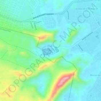
Name: Huacachina topographic map, elevation, terrain.
Location: Huacachina, Ica, Province of Ica, Ica, Peru (-14.08935 -75.76607 -14.08571 -75.75990)
Average elevation: 439 m
Minimum elevation: 394 m
Maximum elevation: 566 m
Thank you for supporting this site ❤️
Make a donation
Make a donation
Gear up for your next adventure:
As an Amazon Associate, this site earns from qualifying purchases at no extra cost to you.