
Guédiawaye Department topographic map
Interactive map
Click on the map to display elevation.
About this map
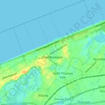
Name: Guédiawaye Department topographic map, elevation, terrain.
Location: Guédiawaye Department, Dakar Region, 15000, Senegal (14.74523 -17.43007 14.81476 -17.35960)
Average elevation: 6 m
Minimum elevation: 0 m
Maximum elevation: 28 m
Other topographic maps
Click on a map to view its topography, its elevation and its terrain.
Tiaroye
Senegal > Dakar Region > Commune de Tivaouane Diacksao
Tiaroye, Commune de Tivaouane Diacksao, Arrondissement de Thiaroye, Pikine Department, Dakar Region, 10000, Senegal
Average elevation: 8 m
Island of Gorée
Senegal > Dakar Region > Dakar
Island of Gorée, Commune de Gorée, Arrondissement de Dakar-Plateau, Dakar, Dakar Region, Senegal
Average elevation: 0 m
Bambylor
Senegal > Dakar Region > Commune de Bambylor > Bambylor
Bambylor, Commune de Bambylor, Arrondissement de Bambylor, Rufisque Department, Dakar Region, Senegal
Average elevation: 24 m
Rufisque
Rufisque, Rufisque Department, Dakar Region, Senegal
Average elevation: 13 m