
Toulouse topographic map
Interactive map
Click on the map to display elevation.
About this map
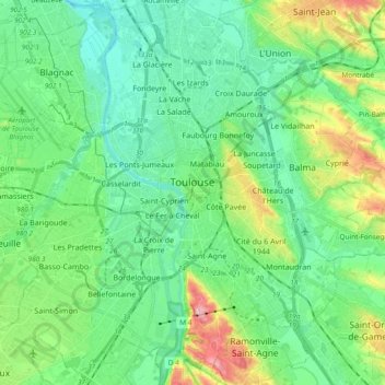
Name: Toulouse topographic map, elevation, terrain.
Location: Toulouse, Haute-Garonne, Occitania, Metropolitan France, France (43.53265 1.35040 43.66871 1.51538)
Average elevation: 155 m
Minimum elevation: 117 m
Maximum elevation: 262 m
The first half of the 14th century was a prosperous period, despite the dismemberment in 1317 of the very large bishopric of Toulouse (which lost two thirds of its area and a large part of its income, a loss only partially compensated by its elevation to the rank of archbishopric), and the episode of the Shepherds' Crusade which brought a pogrom against Toulouse's Jewish population in 1320. In 1335, Toulouse had between 35,000 and 40,000 inhabitants.
Other topographic maps
Click on a map to view its topography, its elevation and its terrain.
Saint-Alban
France > Occitania > Haute-Garonne
Saint-Alban, Toulouse, Haute-Garonne, Occitania, Metropolitan France, 31140, France
Average elevation: 128 m
Prunet
France > Occitania > Haute-Garonne
Prunet, Toulouse, Haute-Garonne, Occitania, Metropolitan France, 31460, France
Average elevation: 234 m
Brax
France > Occitania > Haute-Garonne
Brax, Toulouse, Haute-Garonne, Occitania, Metropolitan France, 31490, France
Average elevation: 194 m
Fronton
France > Occitania > Haute-Garonne
Fronton, Toulouse, Haute-Garonne, Occitania, Metropolitan France, 31620, France
Average elevation: 136 m
Saint-Orens-de-Gameville
France > Occitania > Haute-Garonne
Saint-Orens-de-Gameville, Toulouse, Haute-Garonne, Occitania, Metropolitan France, 31650, France
Average elevation: 165 m
Renneville
France > Occitania > Haute-Garonne
Renneville, Toulouse, Haute-Garonne, Occitania, Metropolitan France, 31290, France
Average elevation: 202 m
Saint-Gaudens
France > Occitania > Haute-Garonne
Saint-Gaudens, Haute-Garonne, Occitania, Metropolitan France, 31800, France
Average elevation: 404 m
Revel
France > Occitania > Haute-Garonne
Revel, Toulouse, Haute-Garonne, Occitania, Metropolitan France, 31250, France
Average elevation: 239 m
Castelginest
France > Occitania > Haute-Garonne
Castelginest, Toulouse, Haute-Garonne, Occitania, Metropolitan France, 31780, France
Average elevation: 138 m
Léguevin
France > Occitania > Haute-Garonne
Léguevin, Toulouse, Haute-Garonne, Occitania, Metropolitan France, 31490, France
Average elevation: 197 m
Lège
France > Occitania > Haute-Garonne
Lège, Saint-Gaudens, Haute-Garonne, Occitania, Metropolitan France, 31440, France
Average elevation: 880 m
Mons
France > Occitania > Haute-Garonne
Mons, Toulouse, Haute-Garonne, Occitania, Metropolitan France, 31280, France
Average elevation: 195 m
Saint-Félix-Lauragais
France > Occitania > Haute-Garonne
Saint-Félix-Lauragais, Toulouse, Haute-Garonne, Occitania, Metropolitan France, 31540, France
Average elevation: 236 m
Saint-Julia
France > Occitania > Haute-Garonne
Saint-Julia, Toulouse, Haute-Garonne, Occitania, Metropolitan France, 31540, France
Average elevation: 235 m
Issus
France > Occitania > Haute-Garonne
Issus, Toulouse, Haute-Garonne, Occitania, Metropolitan France, 31450, France
Average elevation: 211 m
Montesquieu-Guittaut
France > Occitania > Haute-Garonne
Montesquieu-Guittaut, Saint-Gaudens, Haute-Garonne, Occitania, Metropolitan France, 31230, France
Average elevation: 263 m
Labarthe-sur-Lèze
France > Occitania > Haute-Garonne
Labarthe-sur-Lèze, Muret, Haute-Garonne, Occitania, Metropolitan France, 31860, France
Average elevation: 171 m
Latrape
France > Occitania > Haute-Garonne
Latrape, Muret, Haute-Garonne, Occitania, Metropolitan France, 31310, France
Average elevation: 294 m
Mauvezin
France > Occitania > Haute-Garonne
Mauvezin, Saint-Gaudens, Haute-Garonne, Occitania, Metropolitan France, 31230, France
Average elevation: 247 m
Grenade
France > Occitania > Haute-Garonne
Grenade, Toulouse, Haute-Garonne, Occitania, Metropolitan France, 31330, France
Average elevation: 131 m
Cintegabelle
France > Occitania > Haute-Garonne
Cintegabelle, Muret, Haute-Garonne, Occitania, Metropolitan France, 31550, France
Average elevation: 231 m
Cardeilhac
France > Occitania > Haute-Garonne
Cardeilhac, Saint-Gaudens, Haute-Garonne, Occitania, Metropolitan France, 31350, France
Average elevation: 398 m
Toulouse
France > Occitania > Haute-Garonne > Toulouse
Toulouse, Haute-Garonne, Occitania, Metropolitan France, 31080, France
Average elevation: 173 m
Gémil
France > Occitania > Haute-Garonne
Gémil, Toulouse, Haute-Garonne, Occitania, Metropolitan France, 31380, France
Average elevation: 177 m
Montlaur
France > Occitania > Haute-Garonne
Montlaur, Toulouse, Haute-Garonne, Occitania, Metropolitan France, 31450, France
Average elevation: 173 m
Touille
France > Occitania > Haute-Garonne
Touille, Saint-Gaudens, Haute-Garonne, Occitania, Metropolitan France, 31260, France
Average elevation: 341 m
Saint-Léon
France > Occitania > Haute-Garonne
Saint-Léon, Toulouse, Haute-Garonne, Occitania, Metropolitan France, 31560, France
Average elevation: 232 m
Valentine
France > Occitania > Haute-Garonne > Valentine
Valentine, Saint-Gaudens, Haute-Garonne, Occitania, Metropolitan France, 31800, France
Average elevation: 408 m
Saint-Béat-Lez
France > Occitania > Haute-Garonne > Saint-Béat-Lez
Saint-Béat-Lez, Saint-Gaudens, Haute-Garonne, Occitania, Metropolitan France, 31440, France
Average elevation: 872 m
Daux
France > Occitania > Haute-Garonne > Daux
Daux, Toulouse, Haute-Garonne, Occitania, Metropolitan France, 31700, France
Average elevation: 170 m
Conne
France > Occitania > Haute-Garonne > Mane
Conne, Mane, Saint-Gaudens, Haute-Garonne, Occitania, Metropolitan France, 31260, France
Average elevation: 329 m
Cadours
France > Occitania > Haute-Garonne > Cadours
Cadours, Toulouse, Haute-Garonne, Occitania, Metropolitan France, 31480, France
Average elevation: 206 m
Bagnères-de-Luchon
France > Occitania > Haute-Garonne
Bagnères-de-Luchon, Saint-Gaudens, Haute-Garonne, Occitania, Metropolitan France, 31110, France
Average elevation: 1,666 m
Marignac
France > Occitania > Haute-Garonne
Marignac, Saint-Gaudens, Haute-Garonne, Occitania, Metropolitan France, 31440, France
Average elevation: 965 m
Saint-Geniès-Bellevue
France > Occitania > Haute-Garonne > Saint-Geniès-Bellevue
Saint-Geniès-Bellevue, Toulouse, Haute-Garonne, Occitania, Metropolitan France, 31180, France
Average elevation: 191 m
Latour
France > Occitania > Haute-Garonne > Latour
Latour, Muret, Haute-Garonne, Occitania, Metropolitan France, 31310, France
Average elevation: 314 m
Mirambeau
France > Occitania > Haute-Garonne
Mirambeau, Saint-Gaudens, Haute-Garonne, Occitania, Metropolitan France, 31230, France
Average elevation: 230 m
Lux
France > Occitania > Haute-Garonne
Lux, Toulouse, Haute-Garonne, Occitania, Metropolitan France, 31290, France
Average elevation: 238 m
Muret
France > Occitania > Haute-Garonne
Muret, Haute-Garonne, Occitania, Metropolitan France, 31600, France
Average elevation: 190 m
Labège
France > Occitania > Haute-Garonne
Labège, Toulouse, Haute-Garonne, Occitania, Metropolitan France, 31670, France
Average elevation: 165 m
Portet-sur-Garonne
France > Occitania > Haute-Garonne
Portet-sur-Garonne, Muret, Haute-Garonne, Occitania, Metropolitan France, 31120, France
Average elevation: 159 m
Pointis-de-Rivière
France > Occitania > Haute-Garonne
Pointis-de-Rivière, Saint-Gaudens, Haute-Garonne, Occitania, Metropolitan France, 31210, France
Average elevation: 407 m
Chaum
France > Occitania > Haute-Garonne
Chaum, Saint-Gaudens, Haute-Garonne, Occitania, Metropolitan France, 31440, France
Average elevation: 652 m
Aurignac
France > Occitania > Haute-Garonne
Aurignac, Saint-Gaudens, Haute-Garonne, Occitania, Metropolitan France, 31420, France
Average elevation: 364 m
Mondonville
France > Occitania > Haute-Garonne
Mondonville, Toulouse, Haute-Garonne, Occitania, Metropolitan France, 31700, France
Average elevation: 175 m
Albiac
France > Occitania > Haute-Garonne
Albiac, Toulouse, Haute-Garonne, Occitania, Metropolitan France, 31460, France
Average elevation: 210 m
Cox
France > Occitania > Haute-Garonne
Cox, Toulouse, Haute-Garonne, Occitania, Metropolitan France, 31480, France
Average elevation: 253 m
Huos
France > Occitania > Haute-Garonne
Huos, Saint-Gaudens, Haute-Garonne, Occitania, Metropolitan France, 31210, France
Average elevation: 465 m
Tournefeuille
France > Occitania > Haute-Garonne
Tournefeuille, Toulouse, Haute-Garonne, Occitania, Metropolitan France, 31170, France
Average elevation: 165 m