
Kwango topographic map
Interactive map
Click on the map to display elevation.
About this map
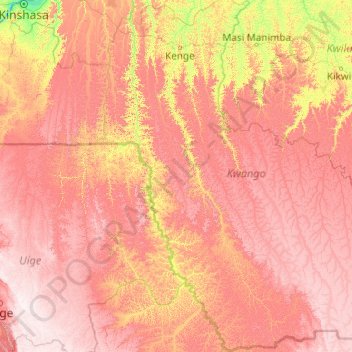
Name: Kwango topographic map, elevation, terrain.
Location: Kwango, Democratic Republic of the Congo (-8.13104 16.11388 -4.23410 19.97523)
Average elevation: 724 m
Minimum elevation: 327 m
Maximum elevation: 1,247 m
Other topographic maps
Click on a map to view its topography, its elevation and its terrain.
Mukombu
Democratic Republic of the Congo > Kwango > Mukombu
Mukombu, Kwango, Democratic Republic of the Congo
Average elevation: 511 m