
Camberwell topographic map
Click on the map to display elevation.
Camberwell
The Prospect Hill Road Precinct area is adjacent to the railway station and is the oldest part of the suburb. The original subdivision was relatively generous blocks, which were quickly filled with fine Victorian and Edwardian houses. Due to its hilly topography, many east–west streets in the Prospect Hill area have an excellent view of Melbourne's Central Business District. Its main commercial centre developed along Burke Road from its railway station to Camberwell Junction, 500 m to the south. Several tram routes converge on this point.
About this map
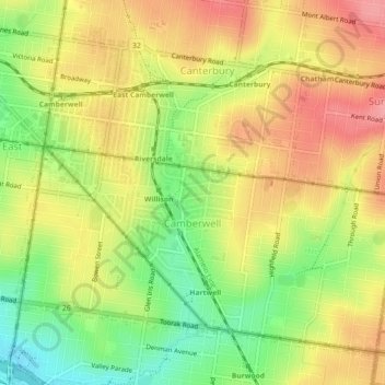
Name: Camberwell topographic map, elevation, terrain.
Average elevation: 66 m
Minimum elevation: 14 m
Maximum elevation: 109 m
Other topographic maps
Click on a map to view its topography, its elevation and its terrain.
Yarra Valley
Australia > Victoria > Melbourne
The Yarra Valley is the region surrounding the Yarra River in Victoria, Australia. The river originates approximately 240 km (150 mi) east of the Melbourne central business district and flows towards it and out into Port Phillip Bay. The name Yarra Valley is used in reference to the upper regions surrounding…
Average elevation: 305 m
Gilbertsons Grassland Nature Conservation Reserve
Australia > Victoria > Melbourne
Average elevation: 36 m
Mount Dandenong
Australia > Victoria > Melbourne
Mount Dandenong has a cool oceanic climate (Cfb), with cool to mild summers and cold, damp winters. Daytime temperatures are usually 4−6 °C cooler than downtown Melbourne due to its elevation and distance from the urban heat island effect of Melbourne. It is significantly cloudier than Melbourne,…
Average elevation: 395 m
Langwarrin Flora and Fauna Reserve
Australia > Victoria > Melbourne > Langwarrin
Average elevation: 90 m
Narre Warren North Retarding Basin (Melbourne Water)
Australia > Victoria > Melbourne
Average elevation: 76 m