
Saint-Blaise topographic map
Interactive map
Click on the map to display elevation.
About this map
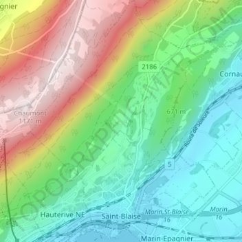
Name: Saint-Blaise topographic map, elevation, terrain.
Location: Saint-Blaise, Neuchâtel, 2072, Switzerland (47.00842 6.96427 47.05134 7.01305)
Average elevation: 687 m
Minimum elevation: 425 m
Maximum elevation: 1,178 m
Other topographic maps
Click on a map to view its topography, its elevation and its terrain.
La Roche
Switzerland > Neuchâtel > La Sagne > La Roche
La Roche, La Sagne, Neuchâtel, 2314, Switzerland
Average elevation: 1,115 m
La Ronde
Switzerland > Neuchâtel > Bernese Jura administrative district > La Chaux-de-Fonds
La Ronde, La Chaux-de-Fonds, Bernese Jura administrative district, Bernese Jura administrative region, Neuchâtel, 2336, Switzerland
Average elevation: 807 m
Lake Neuchâtel
Switzerland > Neuchâtel > Seeland administrative district
Lake Neuchâtel, Seeland administrative district, Seeland administrative region, Neuchâtel, Switzerland
Average elevation: 658 m
Milvignes
Switzerland > Neuchâtel > Milvignes
Milvignes, District de Boudry, Neuchâtel, Switzerland
Average elevation: 573 m
La Chaux-de-Fonds
Switzerland > Neuchâtel > La Chaux-de-Fonds
La Chaux-de-Fonds, District de La Chaux-de-Fonds, Neuchâtel, Switzerland
Average elevation: 1,039 m