
Myrina topographic map
Interactive map
Click on the map to display elevation.
About this map
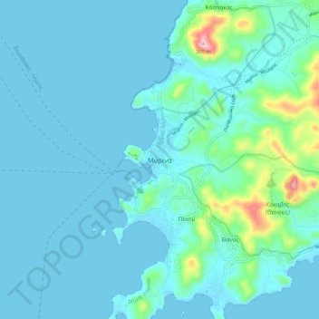
Name: Myrina topographic map, elevation, terrain.
Average elevation: 39 m
Minimum elevation: 0 m
Maximum elevation: 338 m
Other topographic maps
Click on a map to view its topography, its elevation and its terrain.
Σαρδές
Greece > Aegean > Lemnos Regional Unit
Σαρδές, Lemnos Municipality, Lemnos Regional Unit, Northern Aegean, Aegean, 814 00, Greece
Average elevation: 191 m
Lemnos
Greece > Aegean > Lemnos Regional Unit
Lemnos, Lemnos Regional Unit, Northern Aegean, Aegean, Greece
Average elevation: 27 m
Agios Efstratios
Greece > Aegean > Lemnos Regional Unit > Agios Efstratios
Agios Efstratios, Agios Efstratios Municipality, Lemnos Regional Unit, Northern Aegean, Aegean, 815 00, Greece
Average elevation: 38 m
Athira
Greece > Aegean > Lemnos Regional Unit > Athira
Athira, Lemnos Municipality, Lemnos Regional Unit, Northern Aegean, Aegean, 81401, Greece
Average elevation: 32 m