
Thank you for supporting this site ❤️
Make a donation
Make a donation
Gear up for your next adventure:
As an Amazon Associate, this site earns from qualifying purchases at no extra cost to you.
Shusha topographic map
Click on the map to display elevation.
Thank you for supporting this site ❤️
Make a donation
Make a donation
Gear up for your next adventure:
As an Amazon Associate, this site earns from qualifying purchases at no extra cost to you.
About this map
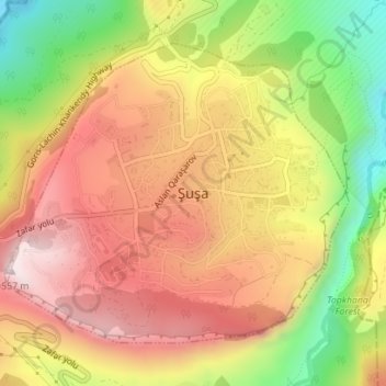
Name: Shusha topographic map, elevation, terrain.
Location: Shusha, Shusha District, Karabakh, AZ5800, Azerbaijan (39.74850 46.73213 39.76945 46.76343)
Average elevation: 1,268 m
Minimum elevation: 923 m
Maximum elevation: 1,537 m
Thank you for supporting this site ❤️
Make a donation
Make a donation
Gear up for your next adventure:
As an Amazon Associate, this site earns from qualifying purchases at no extra cost to you.