
Make a donation
Gear up for your next adventure:
As an Amazon Associate, this site earns from qualifying purchases at no extra cost to you.
Barwani topographic map
Click on the map to display elevation.
Make a donation
Gear up for your next adventure:
As an Amazon Associate, this site earns from qualifying purchases at no extra cost to you.
Barwani
Barwani is located at 22°02′N 74°54′E / 22.03°N 74.9°E / 22.03; 74.9. It has an average elevation of 178 meters (583 feet). The Narmada River flows through Barwani; it is 5 km (3.1 miles) from the city centre. The maximum temperature of Barwani in April and May used to reach 48 °C (118 °F), making it one of the hottest places in Central India. However, in recent years, it has cooled down.
Make a donation
Gear up for your next adventure:
As an Amazon Associate, this site earns from qualifying purchases at no extra cost to you.
About this map
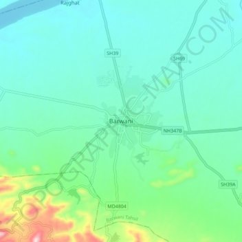
Name: Barwani topographic map, elevation, terrain.
Average elevation: 191 m
Minimum elevation: 113 m
Maximum elevation: 503 m
Make a donation
Gear up for your next adventure:
As an Amazon Associate, this site earns from qualifying purchases at no extra cost to you.