Geolocate

Gifford topographic map

Click on the map to display elevation.

About this map

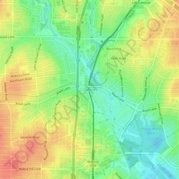
Name: Gifford topographic map, elevation, terrain.

Location: Gifford, Dallas, Dallas County, Texas, 75243, United States (32.87790 -96.78583 32.91790 -96.74583)

Average elevation: 170 m

Minimum elevation: 143 m

Maximum elevation: 197 m

Other topographic maps

Click on a map to view its topography, its elevation and its terrain.

Kessler Parkway

United States > Texas > Dallas County > Dallas

Average elevation: 137 m

Klyde Warren Park

United States > Texas > Dallas County > Dallas

Average elevation: 142 m

Lake Shirley

United States > Texas > Dallas County > Dallas

Average elevation: 199 m

Dealey Plaza

United States > Texas > Dallas County > Dallas

Average elevation: 132 m

Klyde Warren Park

United States > Texas > Dallas County > Dallas

Average elevation: 142 m

Pioneer Park

United States > Texas > Dallas County > Dallas

Average elevation: 135 m

Gear up for your next adventure:

📸Action Camera Chest Mounts - Record your ascent following topographic paths hands-free
🧦Hiking Socks - Breathable socks designed to prevent blisters on long walks
🛰️Outdoor GPS Navigation - Navigation devices for remote and off-grid areas
🧢Hiking Hats - Sun and weather protection for outdoor walks
🔥Emergency Fire Starters - Reliable ignition tools for survival situations in damp conditions

As an Amazon Associate, this site earns from qualifying purchases at no extra cost to you.