Geolocate

Hietzing topographic map

Click on the map to display elevation.

About this map

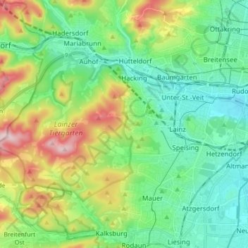
Name: Hietzing topographic map, elevation, terrain.

Location: Hietzing, Vienna, 1130, Austria (48.14946 16.18183 48.20705 16.32013)

Average elevation: 285 m

Minimum elevation: 187 m

Maximum elevation: 515 m

Other topographic maps

Click on a map to view its topography, its elevation and its terrain.

Wienerberg

Austria > Vienna

Average elevation: 223 m

Schonbrunn Palace

Austria > Vienna

Average elevation: 214 m

Belvedere

Austria > Vienna

Average elevation: 190 m

Wienerberg

Austria > Vienna

Average elevation: 223 m

Maurer Wald

Austria > Vienna

Average elevation: 307 m

Belvedere

Austria > Vienna

Average elevation: 190 m

Belvedere

Austria > Vienna

Average elevation: 190 m

People's Garden

Austria > Vienna

Average elevation: 191 m

Herweghpark

Austria > Vienna

Average elevation: 208 m

Simmering

Austria > Vienna

The district lies in the southern part of Vienna. It borders the Danube and Danube Canal to the east and the East railway to the west. Of all the districts, Simmering is the lowest district in terms of elevation.

Average elevation: 184 m

Kongressbad

Austria > Vienna

Average elevation: 242 m

Gear up for your next adventure:

👖Packable Overtrousers - Quick-deploy rain protection for legs in sudden storms
🎒Hiking Child Carriers - Explore the outdoors with the whole family safely
🧊Personal Water Filters - Drink safely from mountain streams marked on your map
📦Dry Bags - Waterproof bags to protect gear from rain
💧Hydration Reservoirs - Convenient water bladders for hands-free drinking on the move

As an Amazon Associate, this site earns from qualifying purchases at no extra cost to you.