
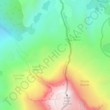
Skinner Glacier topographic map
Interactive map
Click on the map to display elevation.
About this map
Name: Skinner Glacier topographic map, elevation, terrain.
Average elevation: 2,480 m
Minimum elevation: 2,067 m
Maximum elevation: 3,139 m
Other topographic maps
Click on a map to view its topography, its elevation and its terrain.
Portland Downtown
Portland Downtown, Portland, Multnomah County, Oregon, USA
Average elevation: 50 m
Forest Park
Forest Park, Maple Trail, Forest Park, Portland, Multnomah County, Oregon, 97203, USA
Average elevation: 91 m
Cape Meares
USA > Oregon > Cape Meares
Cape Meares, Tillamook County, Oregon, 97134, USA
Average elevation: 52 m
Dunes City
USA > Oregon > Dunes City
Dunes City, Lane County, Oregon, 97493, USA
Average elevation: 23 m
Junction City
USA > Oregon > Junction City
Junction City, Lane County, Oregon, USA
Average elevation: 102 m
Waldo Glacier
Waldo Glacier, Pacific Crest Trail, Jefferson County, Oregon, USA
Average elevation: 2,352 m
Hosford-Abernethy
Hosford-Abernethy, Portland, Multnomah County, Oregon, USA
Average elevation: 26 m
Renfrew Glacier
Renfrew Glacier, climber's trail, Deschutes County, Oregon, USA
Average elevation: 2,538 m
Ladd Glacier
Ladd Glacier, Barrett Spur, Hood River County, Oregon, USA
Average elevation: 2,305 m
Bend Glacier
Bend Glacier, Broken Top NW Ridge route, Deschutes County, Oregon, USA
Average elevation: 2,350 m
Lathrop Glacier
Lathrop Glacier, Mt. Thielsen climber's trail, Douglas County, Oregon, USA
Average elevation: 2,235 m
Coe Glacier
Coe Glacier, Barrett Spur, Hood River County, Oregon, USA
Average elevation: 2,328 m
Glisan Glacier
Glisan Glacier, McNeil Point Trail #600M, Hood River County, Oregon, USA
Average elevation: 2,086 m
Milk Creek Glacier
Milk Creek Glacier, Pacific Crest Trail, Jefferson County, Oregon, USA
Average elevation: 2,508 m
Crook Glacier
Crook Glacier, Broken Top NW Ridge route, Deschutes County, Oregon, USA
Average elevation: 2,347 m
Three Fingered Jack
Three Fingered Jack, Linn County, Oregon, USA
Average elevation: 1,881 m
Hayden Glacier
Hayden Glacier, climber's trail, Deschutes County, Oregon, USA
Average elevation: 2,542 m
White River Glacier
White River Glacier, Mountaineer Trail #798, Clackamas County, Oregon, USA
Average elevation: 2,523 m
Bonny Slope Park
Bonny Slope Park, Cedar Mill, Washington County, Oregon, USA
Average elevation: 182 m
Whitewater Glacier
Whitewater Glacier, Pacific Crest Trail, Jefferson County, Oregon, USA
Average elevation: 2,460 m
Jefferson Park Glacier
Jefferson Park Glacier, Pacific Crest Trail, Jefferson County, Oregon, USA
Average elevation: 2,421 m
Reid Glacier
Reid Glacier, Yocum Ridge Trail #771, Clackamas County, Oregon, USA
Average elevation: 2,410 m
Benson Glacier
Benson Glacier, Eagle Cap Summit Trail, Union County, Oregon, USA
Average elevation: 2,489 m
Lost Creek Glacier
Lost Creek Glacier, South Sister Climber Trail #36, Deschutes County, Oregon, USA
Average elevation: 2,430 m
Villard Glacier
Villard Glacier, climber's trail, Deschutes County, Oregon, USA
Average elevation: 2,448 m
Langille Glacier
Langille Glacier, Eliot west moraine, Hood River County, Oregon, USA
Average elevation: 2,165 m
Hells Canyon National Recreation Area
Hells Canyon National Recreation Area, Wallowa County, Oregon, USA
Average elevation: 1,444 m
Linn Glacier
Linn Glacier, Pacific Crest Trail, Deschutes County, Oregon, USA
Average elevation: 2,359 m
Prouty Glacier
Prouty Glacier, South Sister Climber Trail #36, Deschutes County, Oregon, USA
Average elevation: 2,589 m
Thayer Glacier
Thayer Glacier, climber's trail, Deschutes County, Oregon, USA
Average elevation: 2,423 m
Newton Clark Glacier
Newton Clark Glacier, Cooper Spur Trail #600B, Hood River County, Oregon, USA
Average elevation: 2,589 m