
Poing topographic map
Interactive map
Click on the map to display elevation.
About this map
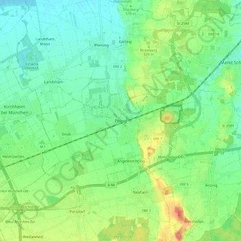
Name: Poing topographic map, elevation, terrain.
Location: Poing, Landkreis Ebersberg, Bavaria, 85586, Germany (48.13205 11.76908 48.21205 11.84908)
Average elevation: 518 m
Minimum elevation: 494 m
Maximum elevation: 570 m
Other topographic maps
Click on a map to view its topography, its elevation and its terrain.
Steinhöring
Germany > Bavaria > Landkreis Ebersberg
Steinhöring, Landkreis Ebersberg, Bavaria, 85643, Germany
Average elevation: 543 m
Hesselfurt
Germany > Bavaria > Landkreis Ebersberg > Grafing > Grafing-Bahnhof
Hesselfurt, Grafing-Bahnhof, Grafing, Baiern (VGem Glonn), Landkreis Ebersberg, Bavaria, 85567, Germany
Average elevation: 541 m
Vaterstetten
Germany > Bavaria > Landkreis Ebersberg
Vaterstetten, Landkreis Ebersberg, Bavaria, Germany
Average elevation: 536 m