
Norwalk topographic map
Interactive map
Click on the map to display elevation.
About this map
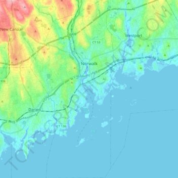
Name: Norwalk topographic map, elevation, terrain.
Location: Norwalk, Fairfield County, Connecticut, United States (41.02045 -73.47457 41.17127 -73.38029)
Average elevation: 24 m
Minimum elevation: -7 m
Maximum elevation: 145 m
Norwalk's topography is dominated by its coastline along Long Island Sound, the Norwalk River and its eastern and western banks, and the Norwalk Islands. The highest elevation is 315 feet (96 m) above sea level on the fairway of the 16th hole of the Silvermine Golf Course, and the low elevation is sea level on Long Island Sound.