
Finsterwalde topographic map
Interactive map
Click on the map to display elevation.
About this map
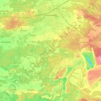
Name: Finsterwalde topographic map, elevation, terrain.
Location: Finsterwalde, Elbe-Elster, Brandenburg, 03238, Germany (51.51867 13.62674 51.65595 13.81427)
Average elevation: 113 m
Minimum elevation: 62 m
Maximum elevation: 170 m
Other topographic maps
Click on a map to view its topography, its elevation and its terrain.
Bad Liebenwerda
Germany > Brandenburg > Elbe-Elster
Bad Liebenwerda, Liebenwerda, Elbe-Elster, Brandenburg, 04924, Germany
Average elevation: 94 m