
Make a donation
Gear up for your next adventure:
As an Amazon Associate, this site earns from qualifying purchases at no extra cost to you.
Kedougou topographic map
Click on the map to display elevation.
Make a donation
Gear up for your next adventure:
As an Amazon Associate, this site earns from qualifying purchases at no extra cost to you.
Kedougou
Kédougou (Wolof: Keédugu) is a town in the Kédougou Region of south-eastern Senegal near the border with Mali and Guinea. It lies at an elevation of 167 m (548 ft) above sea level.
Make a donation
Gear up for your next adventure:
As an Amazon Associate, this site earns from qualifying purchases at no extra cost to you.
About this map
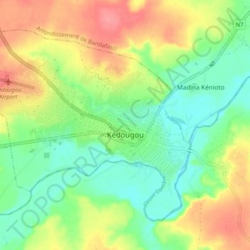
Name: Kedougou topographic map, elevation, terrain.
Average elevation: 133 m
Minimum elevation: 101 m
Maximum elevation: 175 m
Make a donation
Gear up for your next adventure:
As an Amazon Associate, this site earns from qualifying purchases at no extra cost to you.
Other topographic maps
Click on a map to view its topography, its elevation and its terrain.
Make a donation
Gear up for your next adventure:
As an Amazon Associate, this site earns from qualifying purchases at no extra cost to you.
Island of Gorée
Senegal > Dakar Region > Dakar
Recently, Hamady Bocoum et Bernard Toulier published an article "The Fabrication of Heritage: the case of Gorée (Senegal)" (in French: "La fabrication du Patrimoine: l’exemple de Gorée (Sénégal)") documenting the elevation of Gorée to an emotionally charged memorial of the transatlantic slave trade for…
Average elevation: 0 m
Make a donation
Gear up for your next adventure:
As an Amazon Associate, this site earns from qualifying purchases at no extra cost to you.
Make a donation
Gear up for your next adventure:
As an Amazon Associate, this site earns from qualifying purchases at no extra cost to you.
Make a donation
Gear up for your next adventure:
As an Amazon Associate, this site earns from qualifying purchases at no extra cost to you.
Make a donation
Gear up for your next adventure:
As an Amazon Associate, this site earns from qualifying purchases at no extra cost to you.
Make a donation
Gear up for your next adventure:
As an Amazon Associate, this site earns from qualifying purchases at no extra cost to you.
Island of Gorée
Senegal > Dakar Region > Dakar
Recently, Hamady Bocoum et Bernard Toulier published an article "The Fabrication of Heritage: the case of Gorée (Senegal)" (in French: "La fabrication du Patrimoine: l’exemple de Gorée (Sénégal)") documenting the elevation of Gorée to an emotionally charged memorial of the transatlantic slave trade for…
Average elevation: 0 m
Make a donation
Gear up for your next adventure:
As an Amazon Associate, this site earns from qualifying purchases at no extra cost to you.
Make a donation
Gear up for your next adventure:
As an Amazon Associate, this site earns from qualifying purchases at no extra cost to you.
Make a donation
Gear up for your next adventure:
As an Amazon Associate, this site earns from qualifying purchases at no extra cost to you.