Geolocate

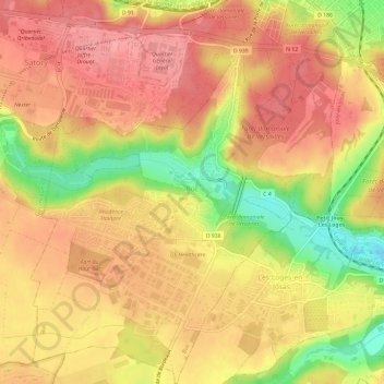
Buc topographic map

Click on the map to display elevation.

Buc

The old town lies in the valley of the River Bièvre at an elevation of around 100 m above sea level. Most of Buc's residential districts have been built on the plateau de Saclay, some 50 m higher.

Wikipedia (CC-BY-SA 3.0)

About this map

Name: Buc topographic map, elevation, terrain.

Location: Buc, Versailles, Yvelines, Ile-de-France, Metropolitan France, 78530, France (48.75419 2.10100 48.79300 2.14872)

Average elevation: 151 m

Minimum elevation: 90 m

Maximum elevation: 183 m

Other topographic maps

Click on a map to view its topography, its elevation and its terrain.
Hautvilliers

France > Ile-de-France > Yvelines > Chevreuse

Average elevation: 127 m

Rodon

France > Ile-de-France > Yvelines

Average elevation: 167 m

La Corse

France > Ile-de-France > Yvelines > Élancourt

Average elevation: 165 m

Gear up for your next adventure:

🔥Emergency Fire Starters - Reliable ignition tools for survival situations in damp conditions
🧵Survival Paracord - Multi-purpose cordage for emergency repairs and shelters
🧘Folding Sit Mats - Dry and warm seat for map-reading breaks on damp ground
🧤Waterproof Overmitts - Extreme weather protection for hikers and mountaineers
Lightweight Solo Tents - Backpacking tents designed for wild camping in the UK highlands

As an Amazon Associate, this site earns from qualifying purchases at no extra cost to you.