Geolocate

Vance topographic map

Click on the map to display elevation.

About this map

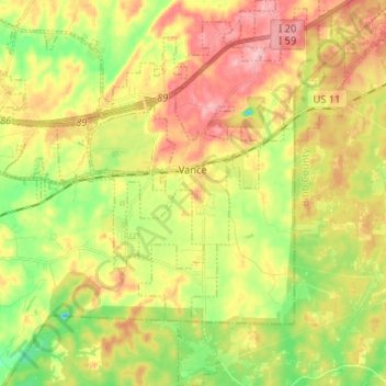
Name: Vance topographic map, elevation, terrain.

Location: Vance, Tuscaloosa County, Alabama, United States (33.11332 -87.29760 33.22229 -87.17843)

Average elevation: 151 m

Minimum elevation: 82 m

Maximum elevation: 222 m

Other topographic maps

Click on a map to view its topography, its elevation and its terrain.

Ralph

United States > Alabama > Tuscaloosa County

Average elevation: 60 m

South Ridge

United States > Alabama > Tuscaloosa County

Average elevation: 60 m

Bull City

United States > Alabama > Tuscaloosa County

Average elevation: 161 m

Carmel Bay

United States > Alabama > Tuscaloosa County

Average elevation: 82 m

Gear up for your next adventure:

🛰️Outdoor GPS Navigation - Navigation devices for remote and off-grid areas
🧗Locking Carabiners - Secure gear to your pack or for light technical use
🧭Orienteering Compasses - Accurate compasses for map-based navigation
🐕Dog Hiking Gear - Equipment for hiking safely with dogs
🔦Waterproof LED Headlamps - Hands-free lighting for evening treks and emergency navigation

As an Amazon Associate, this site earns from qualifying purchases at no extra cost to you.