Geolocate

Tel-Aviv topographic map

Interactive map

Click on the map to display elevation.

About this map

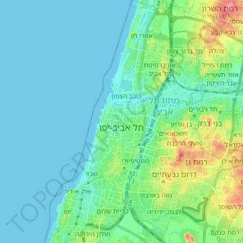
Name: Tel-Aviv topographic map, elevation, terrain.

Location: Tel-Aviv, Tel Aviv Subdistrict, Tel-Aviv District, Israel (32.02934 34.73913 32.14698 34.85226)

Average elevation: 17 m

Minimum elevation: 0 m

Maximum elevation: 89 m

Other topographic maps

Click on a map to view its topography, its elevation and its terrain.

Azor

Israel > Tel-Aviv District

Average elevation: 28 m

Ramat HaSharon

Israel > Tel-Aviv District

Average elevation: 45 m

Bnei Brak

Israel > Tel-Aviv District

Average elevation: 33 m

Herzliya

Israel > Tel-Aviv District

Average elevation: 34 m

Ramat Gan

Israel > Tel-Aviv District

Average elevation: 35 m

Jaffa

Israel > Tel-Aviv District > Tel-Aviv

Average elevation: 12 m

Bat Yam

Israel > Tel-Aviv District

Average elevation: 21 m