
Ural Mountains topographic map
Interactive map
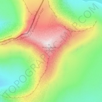
Click on the map to display elevation.
About this map
Name: Ural Mountains topographic map, elevation, terrain.
Average elevation: 1,435 m
Minimum elevation: 1,101 m
Maximum elevation: 1,893 m
The Ural Mountains (/ˈjʊərəl/ YOOR-əl; Russian: Ура́льские го́ры, tr. Uralskiye gory, IPA: [ʊˈralʲskʲɪjə ˈɡorɨ]; Bashkir: Урал тауҙары) or simply the Urals, are a mountain range in Eurasia that runs north-south mostly through Russia, from the coast of the Arctic Ocean to the river Ural and northwestern Kazakhstan. The mountain range forms part of the conventional boundary between the regions of Europe and Asia. Vaygach Island and the islands of Novaya Zemlya form a further continuation of the chain to the north into the Arctic Ocean. The average altitudes of the Urals are around 1,000–1,300 metres (3,300–4,300 ft), the highest point being Mount Narodnaya, which reaches a height of 1,894 metres (6,214 ft).
Other topographic maps
Click on a map to view its topography, its elevation and its terrain.
Хурумпауль
Russia > Khanty-Mansiysk Autonomous Okrug – Ugra > Beryozovsky District
Хурумпауль, сельское поселение Саранпауль, Beryozovsky District, Khanty-Mansiysk Autonomous Okrug – Ugra, Ural Federal District, Russia
Average elevation: 21 m
Сохсъя
Russia > Khanty-Mansiysk Autonomous Okrug – Ugra > Beryozovsky District
Сохсъя, Beryozovsky District, Khanty-Mansiysk Autonomous Okrug – Ugra, Ural Federal District, Russia
Average elevation: 30 m
Mount Narodnaya
Russia > Khanty-Mansiysk Autonomous Okrug – Ugra > Beryozovsky District
Mount Narodnaya, Beryozovsky District, Khanty-Mansiysk Autonomous Okrug – Ugra, Ural Federal District, Russia
Average elevation: 1,437 m