
Thank you for supporting this site ❤️
Make a donation
Make a donation
Gear up for your next adventure:
As an Amazon Associate, this site earns from qualifying purchases at no extra cost to you.
Kabarnet topographic map
Click on the map to display elevation.
Thank you for supporting this site ❤️
Make a donation
Make a donation
Gear up for your next adventure:
As an Amazon Associate, this site earns from qualifying purchases at no extra cost to you.
About this map
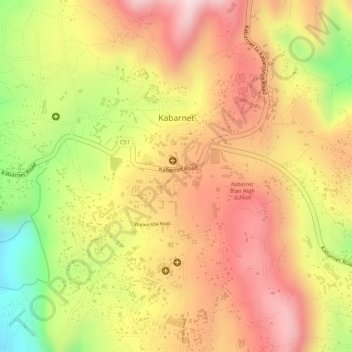
Name: Kabarnet topographic map, elevation, terrain.
Location: Kabarnet, Baringo Central, Baringo, 30400, Kenya (0.48215 35.72729 0.50184 35.75441)
Average elevation: 2,010 m
Minimum elevation: 1,762 m
Maximum elevation: 2,169 m
Thank you for supporting this site ❤️
Make a donation
Make a donation
Gear up for your next adventure:
As an Amazon Associate, this site earns from qualifying purchases at no extra cost to you.