
Tacuarembó topographic map
Interactive map
Click on the map to display elevation.
About this map
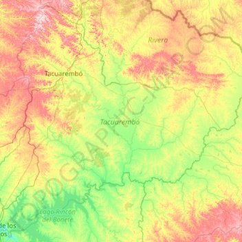
Name: Tacuarembó topographic map, elevation, terrain.
Location: Tacuarembó, Uruguay (-32.86648 -56.68328 -31.23071 -54.66736)
Average elevation: 154 m
Minimum elevation: 56 m
Maximum elevation: 416 m
Other topographic maps
Click on a map to view its topography, its elevation and its terrain.
Chamberlain
Uruguay > Tacuarembó > Chamberlain
Chamberlain, Tacuarembó, 45100, Uruguay
Average elevation: 121 m