Geolocate

Datil topographic map

Click on the map to display elevation.

About this map

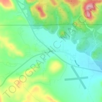
Name: Datil topographic map, elevation, terrain.

Location: Datil, Catron County, New Mexico, United States (34.12503 -107.86336 34.16503 -107.82336)

Average elevation: 2,279 m

Minimum elevation: 2,221 m

Maximum elevation: 2,398 m

Gear up for your next adventure:

🥾Hiking Boots - Waterproof and durable boots for long-distance hiking in the UK
🧗Locking Carabiners - Secure gear to your pack or for light technical use
👟Men's Trail Running Shoes - Lightweight grip for fast movement over topographic contours
🧼Technical Clothing Wash - Special soap to clean and restore waterproof membranes
🧥Softshell Jackets - Breathable jackets for active outdoor use

As an Amazon Associate, this site earns from qualifying purchases at no extra cost to you.