Geolocate

Macabebe topographic map

Click on the map to display elevation.

About this map

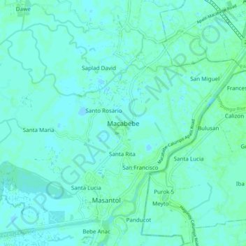
Name: Macabebe topographic map, elevation, terrain.

Location: Macabebe, Pampanga, Central Luzon, 2018, Philippines (14.86961 120.67552 14.94961 120.75552)

Average elevation: 3 m

Minimum elevation: -2 m

Maximum elevation: 7 m

Other topographic maps

Click on a map to view its topography, its elevation and its terrain.

Santa Catalina

Philippines > Pampanga > San Luis

Average elevation: 6 m

Macabebe

Philippines > Pampanga

Average elevation: 2 m

Gulap

Philippines > Pampanga > Candaba

Average elevation: 7 m

Lourdes

Philippines > Pampanga > Candaba

Average elevation: 10 m

Gear up for your next adventure:

🧥Breathable Waterproof Jackets - Essential rain protection for the unpredictable British climate
🥾Men's Waterproof Hiking Boots - Durable footwear with deep lugs for muddy and rocky UK terrains
🧰First Aid Kits - Essential safety kits for outdoor activities
Lightweight Solo Tents - Backpacking tents designed for wild camping in the UK highlands
🧢Thermal Beanie Hats - Prevent heat loss from the head in windy summit conditions

As an Amazon Associate, this site earns from qualifying purchases at no extra cost to you.