
Lancaster topographic map
Interactive map
Click on the map to display elevation.
About this map
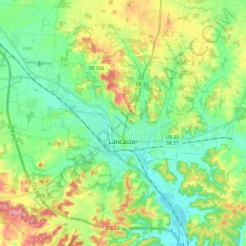
Name: Lancaster topographic map, elevation, terrain.
Location: Lancaster, Fairfield County, Ohio, 43130, United States (39.68739 -82.69342 39.75955 -82.52394)
Average elevation: 283 m
Minimum elevation: 237 m
Maximum elevation: 376 m
Other topographic maps
Click on a map to view its topography, its elevation and its terrain.
Rising Park
United States > Ohio > Fairfield County > Lancaster
Rising Park, Lancaster, Pleasant Township, Fairfield County, Ohio, United States
Average elevation: 274 m
Whites
United States > Ohio > Fairfield County > Lancaster > Whites
Whites, Lancaster, Fairfield County, Ohio, 43130, United States
Average elevation: 262 m